Nantahala National Forest in NC, Sumter National Forest in SC, Chattahoochee National Forest in GA
Work opposing this controversial timber project in the Nantahala Ranger District began in 2017. The project targets rare old-growth trees and stands over 100 years old. Our efforts primarily focused on preserving two stands of timber on Brushy Mountain adjacent to the Ellicott Rock Wilderness Area and the Chattooga River—one stand of old growth, and the other with documented populations of the imperiled Green Salamander. The Brushy Mountain stands sold in August of 2022.
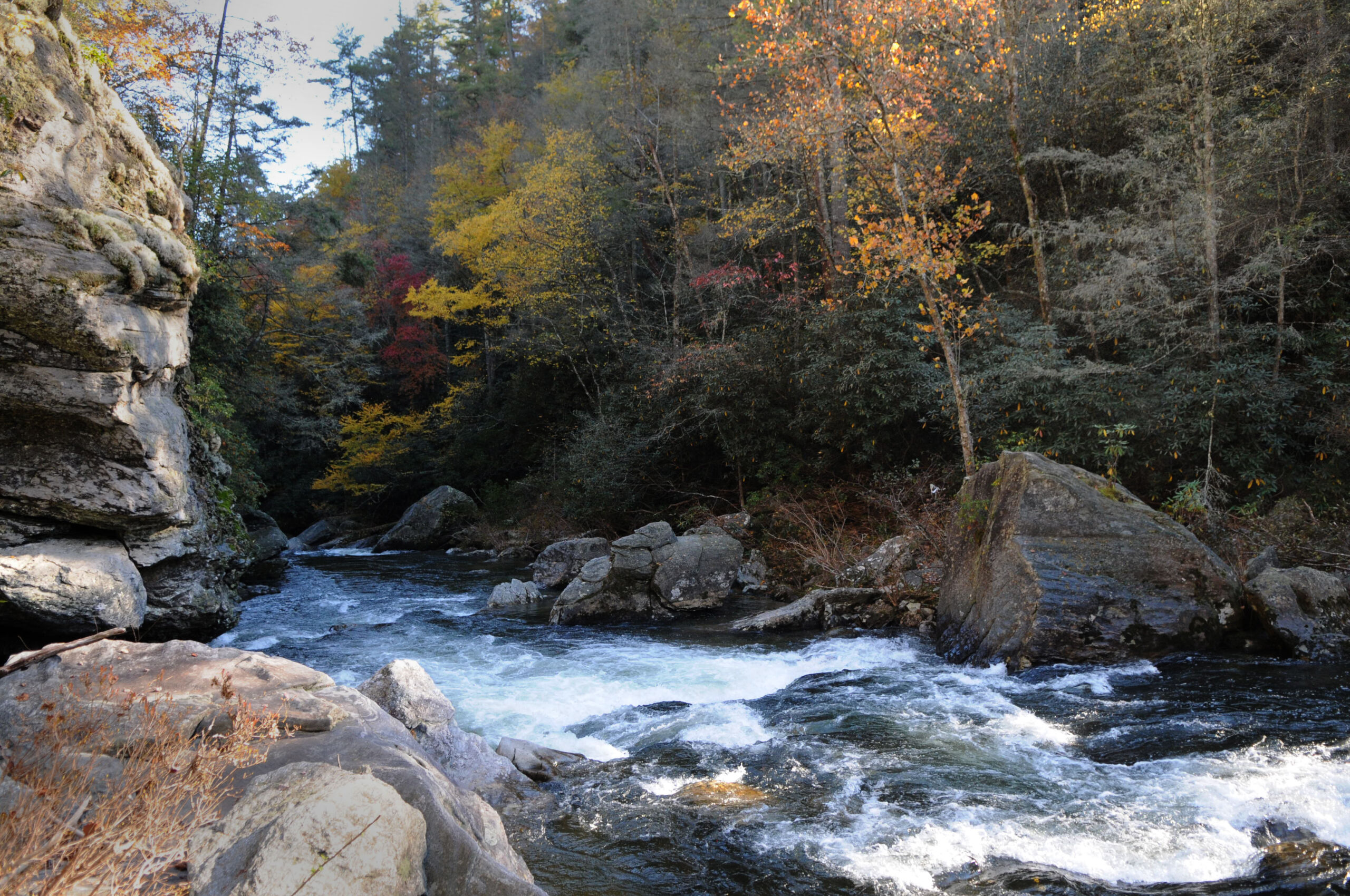
In January of 2024, we joined a coalition of conservation organizations in filing a federal lawsuit against the US Forest Service regarding one stand next to the Whitewater River in NC. The new Nantahala-Pisgah Forest Plan (2023) designated this area as a “Special Interest Area” for its exceptional biodiversity and ecological values; however, the stand is still scheduled to be logged by the Southside Project. Destructive projects like logging and road-building are restricted in Special Interest Areas, yet the Forest Service is poised to violate its own Forest Plan by plowing ahead with this reckless project.
After a multi-year revision process, the new Nantahala-Pisgah Forest Plan was finalized in 2023. The plan will govern national forest management in the Chattooga headwaters in NC for the next 20-30 years. We advocated for greater protection of unique resources through designating Terrapin Mountain, Overflow Wilderness Study Area, and the Ellicott Rock West Extension as potential wilderness areas, and endorsed wild & scenic river eligibility for Overflow Creek and its East & West Forks, the Whitewater River, and the Thompson River. Unfortunately, the final plan falls short on many levels and fails to adequately protect the exceptional values of the Nantahala and Pisgah National Forests. More than 14,000 people objected to the new Forest Plan. Moving forward, we are monitoring for local-level timber projects proposed by the Nantahala Ranger District as per the new Forest Plan.
Read more on the Nantahala-Pisgah Forest Plan Revision page.
This massive Forest Service timber project encompasses 143,419 acres of the Chattahoochee National Forest, including a large portion of the Chattooga River watershed in Rabun County. The project involves up to 55,000 acres of commercial timber harvest, 90,000 acres of non-commercial harvest, herbicide applications on over 60,000 acres, and forest thinning just about everywhere. The project’s final environmental assessment and decision notice were approved in April 2022. We are monitoring this large project through involvement with the ongoing “Foothills Collaborative Group,” an assembly of interested citizens, agencies, and NGOs.
GA Members of Congress in alliance with Secretary of Agriculture Sonny Perdue inserted language into the 2018 Farm Bill that authorized the sale of 3,841 acres of national forest land in the Chattahoochee-Oconee National Forest, which included 8 tracts in Rabun County totaling 1,246 acres. Backed by overwhelming citizen support in Rabun County, we successfully opposed selling these public lands and are continuing oversight of this ill-advised initiative. “Keep public lands in public hands!”
This ongoing Forest Service project involves cutting 6,089 acres of non-native loblolly stands, burning 4,369 acres, applying herbicides on at least 5,542 acres, 57 miles of road maintenance/reconstruction, 37 miles of temporary roads, and 8 miles of bulldozer fire lines. The Forest Service planted loblolly monocultures about 60 years ago, and now supports eradicating the species from the area through clearcutting. We are monitoring this large project to document and publicize its environmental impacts.
This Forest Service project involves harvesting approximately 2,148 acres of “off-site” Eastern white pine, followed by herbicides, prescribed burning, chipping, and/or planting other species of pine trees. Although white pine is a native species, the Forest Service insists certain stands are growing in wrong areas. We’re monitoring the project to document and publicize its environmental impacts.
The Southern Environmental Law Center filed a new, groundbreaking lawsuit in Feb. 2024, alleging that the Forest Service’s practice of setting “timber targets” puts the climate at risk, violates federal law, and undermines important work to mitigate climate change. We are a plaintiff in this lawsuit, along with MountainTrue, and an individual in Missouri. The case centers around the Forest Service’s failure to properly study the massive climate impacts of its timber targets, and the logging projects the agency designs to fulfill them, and targets the Forest Service’s timber program in the agency’s Region 8 and Region 9 (encompassing 33 eastern states and Puerto Rico).
The Climate Forests Campaign is a national coalition of organizations working to conserve mature and old growth trees on federal public lands as one of our country’s most straightforward, impactful and cost-effective climate solutions. We endorse this campaign and are working with partners to protect mature and old-growth trees and forests from logging across America’s public lands as a cornerstone of U.S. climate policy.


We are working to restore stands of native river cane (Arundinaria gigantea) along the Chattooga River near the Highway 28 Bridge and in the vicinity of Chattooga Old Town, in cooperation with the Eastern Band of the Cherokee Indians (EBCI), Revitalization of Cherokee Artisan Resources (RTCAR), and the Andrew Pickens Ranger District. The project aims to establish a sizeable canebrake–one of the most endangered ecosystems in the Southeast–which would benefit water quality, support native species of flora and fauna, and provide raw materials for Cherokee artisans.
Read more on the Native River Cane Restoration Project page.
We’re managing a grant from the GA Department of Natural Resources aimed at reducing sources of pollution into Warwoman Creek on national forest lands in the Earl’s Ford Road area of Rabun Co. Warwoman Creek is a polluted tributary to the Chattooga. The grant also funds an agricultural best management practices project on private land next to Tuckaluge Creek (tributary to Warwoman Creek), and an educational seminar on septic system maintenance in collaboration with the Rabun Co. Health Department.
Read more about the Warwoman Creek Watershed Management Plan.
We are managing a grant from the SC Department of Health & Environmental Control to write a “Watershed Plan” for the Chauga River. The Chauga River watershed lies entirely in Oconee County, SC, provides drinking water for the City of Westminster, and is comprised of both private and public lands in the Andrew Pickens Ranger District. The Chauga Watershed Plan will follow the EPA’s 9-element watershed planning process, to identify causes and sources of pollution and provide a framework for improving water quality through implementation of best management practices.
We are collaborating with the EBTJV to conduct community outreach and education on Brook Trout and restoration in the Chattooga Watershed. This includes 1) Community informational meetings in three key areas of our watershed (Long Creek, Cashiers/Highlands, and Clayton), 2) Outreach to private landowners (select postcard mail outs, educational digital media, etc.) to provide links to information about the benefits of riparian buffers on their land and contact information for assistance with riparian area restoration, and 3) Creating educational materials on Brook Trout health and restoration, made available to local schools.
Tugalo Dam was built in 1923, burying the last 4 miles of the Chattooga and 2 miles of the Tallulah–and the confluence of these two magnificent rivers–for over a century. The Federal Energy Regulatory Commission (FERC) proceedings for considering relicensing Tugalo Dam will begin in 2031. This presents an opportunity to decommission the old Tugalo Dam and restore the inundated reaches of these two iconic rivers and surrounding landscape, which ranks as one of the most biologically diverse in the world.
We organize and lead hands-on work to eradicate non-native invasive species (kudzu, etc.) in the Chattooga River corridor, perform trash clean-ups, and conduct regular water sampling using “Adopt A Stream” methods to test water samples in tributaries to the Chattooga for turbidity, E. coli and fecal coliform pollution.
We’re on the steering committee of “Develop Cashiers Responsibly” (DCR), a citizens group formed in Nov. 2020 to challenge approval of a mega-development at The Crossroads in the center of town, which was defeated. Now DCR is challenging a second proposed mega-development at The Crossroads, while working to influence Jackson County zoning and environmental protection provisions for Cashiers that should help preserve the Chattooga’s water quality.
Private companies won approval to dredge wetlands and other portions of Cashiers Lake prior to building a high-density residential development there. Cashiers Lake feeds the Chattooga headwaters, which are classified as “Outstanding Resource Waters” in the State of NC. We’re monitoring this project.
The High Hampton Resort in Cashiers is undergoing major redevelopment, which began in 2019. We alleged that the massive land-disturbing activities caused severe sediment impacts to Fowler Creek, a wild trout stream and headwater tributary to the Chattooga River. Together with a private landowner, we filed a Clean Water Act lawsuit against the High Hampton developers, which was settled in December 2022. As per the settlement terms, we’re monitoring certain ongoing ground-disturbing actions at the resort, to help protect and restore water quality in the Chattooga River watershed.
The Georgia Department of Transportation has imminent plans to widen Highway 441 North, from Clayton to the NC state line. The project area includes 3 linear miles of Stekoa Creek. Monitoring this project is ongoing.
Over the course of approximately 5 years (2010-2014), Chattooga Conservancy restored 4 degraded acres along Stekoa Creek, created Stekoa Creek Park, and then donated the land to the City of Clayton. Our project demonstrated how abused land along a polluted stream could be restored as green space and become an asset to the community. Stekoa Creek is a polluted tributary to the Chattooga. We hold a conservation easement on Stekoa Creek Park and maintain a stewardship interest in its management.
A 56-acre tract of undeveloped forest land in Rabun County was donated to the Chattooga Conservancy in 2020. We are implementing various projects on the tract consistent with our organizational mission, including plans to develop this land for environmental education initiatives.
Chattooga Conservancy is an accredited land trust as recognized by the Land Trust Alliance. We work with willing landowners to protect special lands through placing conservation easements on qualified properties, and we also accept donations of undeveloped land.

