By Ben Drew
It turns out there are old growth trees around the Upper Whitewater River, but the Forest Service still doesn’t seem to care. Over the past few months, the Forest Service’s commercial timber sale and logging known as the Southside Project has gotten quite a lot of opposition from the public and attention from the press. Most people are outraged at the idea of cutting old growth stands in the headwaters of the Chattooga. Despite the overwhelming public disapproval, the Forest Service has decided to move forward without compromise. As disheartening as this is, there is still hope for stopping parts of the project through the Nantahala-Pisgah Forest Plan revision. In the past, the main focus of this resistance has been on the headwaters of the Chattooga, but a major part of the Southside Project includes stands alongside the Upper Whitewater. The focus of this article is to tell the story of my own experience of the magnificent Upper Whitewater River, explain the threat against it and highlight the path for anyone to join the resistance against the Southside Project through the new Forest Plan revision.
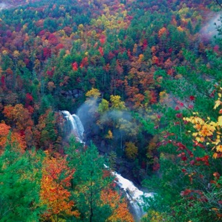
The Upper Whitewater River is one of the six rivers of the Blue Ridge Escarpment. The Escarpment is the natural border marking the end of the Piedmont province and the beginning of the Appalachian Blue Ridge. The rivers of the escarpment, including the Whitewater, are home to countless rare species of flora and fauna because of their unique characteristics. From the point where the Whitewater nears Highway 107 (approx. 3200 feet) to the time it enters Lake Jocassee (approx. 1200 feet), the river drops around 2000 feet in elevation over the course of about 6 miles. Over this distance, it flows through a tight slot canyon unlike any other in the South, has many spray zones from waterfalls that are home to rare species, and its banks humbly hold some of the last remaining old growth in the Southeast.
I first saw Upper Whitewater Falls years ago around October when driving down Highway 281, heading home from kayaking somewhere. Driving up to one of the highest points on the ridge, I noticed what looked like a small trail going up to the top where I figured there might be a nice view of the leaves changing colors. On a whim, I pulled over to the side of the road and walked up the trail. Reaching the top, I was awestruck by the huge waterfall that roared through the deep valley below. By no means did I expect to see a cascade of its size. Nestled among the orange, red, yellow and green leaves of late fall, I remember chuckling to myself about how ridiculous it was that I had decided to stop and see what was over the ridge.
Flash forward a few years and a handful of visits to the lower part of the Whitewater River; I found myself in a kayak at the Highway 107 put-in for the Upper Whitewater. With the river rolling slowly, friends and I meandered our way down stream. The river continued that way for the first mile until the gradient picked up. Shortly after, we arrived at the entrance of the mini gorge. It was unlike anything else I had ever seen in the Southeast. The water bounced its way down slides, off drops and ripped its way through gorge walls so tight that in some places you could touch both sides holding your paddle straight across. I have heard kayaking in the Jocassee watershed described several times as, “like kayaking off the side of a mountain,” and I would say that paddling on the Upper Whitewater held pretty true to this standard.
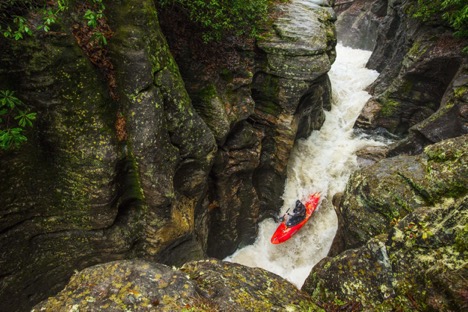
Standing on a rocky outcropping looking down into the deep gorge carved out by the sheer force of the Whitewater River, I was once again mesmerized by the beauty of the water. The force of its impact on the landscape was visible through the potholes and waves carved in the rock extending from the riverbed, and the moss and lichen living off of the spray in the walls of the gorge. The trees reaching over the gorge made it seem like a tunnel to the center of the earth. Looking around, deep in the valley, surrounded by thick rhododendron and trees where the branches nearly touched the opposite river bank, I could have easily been fooled to believe we were the only people on the planet. After the mini gorge, we paddled down the big slides and drops until we got to highway 281 where we had left a car so that we could get out above Upper Whitewater Falls.
Since this exposure to the most intimate gorge of the escarpment I have ever experienced, I have come to learn a lot about the Whitewater River, especially the upper section and its contribution to the region’s biodiversity. The big waterfalls throughout the river create habitats known as “spray zones” that receive overwhelming amounts of spray water from their proximity to waterfalls. These areas host all sorts of rare species that are unable to survive in areas of normal climate. For example, according to a study by Charles Zartman and Dan Pittillo, “268 species of mosses–more species than found in the entire state of California- have been recorded from the Whitewater Gorge.” All of this leads to the Whitewater Gorge being one of the most biodiverse areas in the Southeast. (Zartman and Pittillo, 1995) I have also learned about the history of logging in the area as a result of hiking around the peaks along the Upper Whitewater. Most of the national forest land on the south side of the river around the Foothills Trail has been logged in the past. However, if you’re out walking through the woods, every now again you might find yourself in a patch that was left unharmed.

Walking through one of these stands, Buzz Williams and I saw a White Oak. It was not particularly impressive looking– in fact, there were many other trees in sight that I felt would be better to collect data on. However, after reviewing what we collected, we found the tree to be over 200 years old! Unfortunately, these are just the scraps of the once old and thriving trees that filled the area. They may not look like much, or appear to be as large as the trees that most people associate with old growth, but they are the last mature pieces maintaining connectivity in the Upper Whitewater’s forests.
Through the justification of a commercial timber sale, the Southside Project is planning to log what is left. Within the southwest rim of the gorge, 2 stands will be logged, one of which is planned to be cut all the way down to the edge of the river. Beyond the rim of the gorge, between Highway 107 and 281, 7 more stands will be cut. Some of them sit directly next to the heads of springs that feed the Upper Whitewater. The effects on water quality could be horrendous from sediment-packed runoff and the use of harmful chemicals to prevent invasive species and whatever else the Forest Service does not want to grow back after the cut. The rare spay zone habitats would be affected, and the mature integrity of the forest would be lost.
However, this isn’t to say that something cannot be done. Because of the Upper Whitewater’s beauty and relative ecological health, it has been proposed as a river to be deemed eligible for Wild and Scenic designation. If it was recognized as simply being eligible for wild and scenic designation, some of these stands would have to be dropped from the project. The way this can be done is through the Nantahala-Pisgah Forest Plan Revision. The draft of this revised forest plan will likely be released for public comment sometime this summer. If the public expresses enough desire for designating the Upper Whitewater as eligible for wild & scenic designation, the Forest Service will be forced to consider it and potentially drop these stands of the Southside Project. As of a recent stakeholders meeting with the Forest Service,The Nantahala-Pisgah Forest Partnership has endorsed this designation for the Upper Whitewater. However, it is still up to us to let the Forest Service and these groups know how important it is to us that the Upper Whitewater be recognized as eligible for wild and scenic designation. The next commenting period for the Forest Plan Revision will open when the next draft plan is released at the end of Summer 2019, and it is crucial the public’s voice is heard through this process. You as taxpayers pay Forest Service salaries and their job is to serve YOU. Tell them what you want. The Upper Whitewater is not for the taking.
In summary, if you haven’t been out to sections of the Whitewater River, go. There are hiking trails along the upper and lower sections, and the Foothills Trail even crosses it. Go see the falls, it’s hard not to be impressed. The Forest Service is doing their best to log along the Upper Whitewater, but if we show them how important it is to us, they’ll be forced to reconsider. The best way to show them is by commenting on the Forest Plan Revision and asking for the Upper Whitewater to be deemed eligible for wild and scenic status. If the Whitewater is deemed eligible, not only will it save the stands with old growth characteristics, but it would ensure the integrity of the river for future generations. Go tell the Forest Service what is important to you.
Reference:
Zartman, C., Pittillo, J. D. (1995). An Inventory of Spray Cliff Plant Communities in the Chattooga Basin. Western Carolina and Highland Biological Station, 3-10.