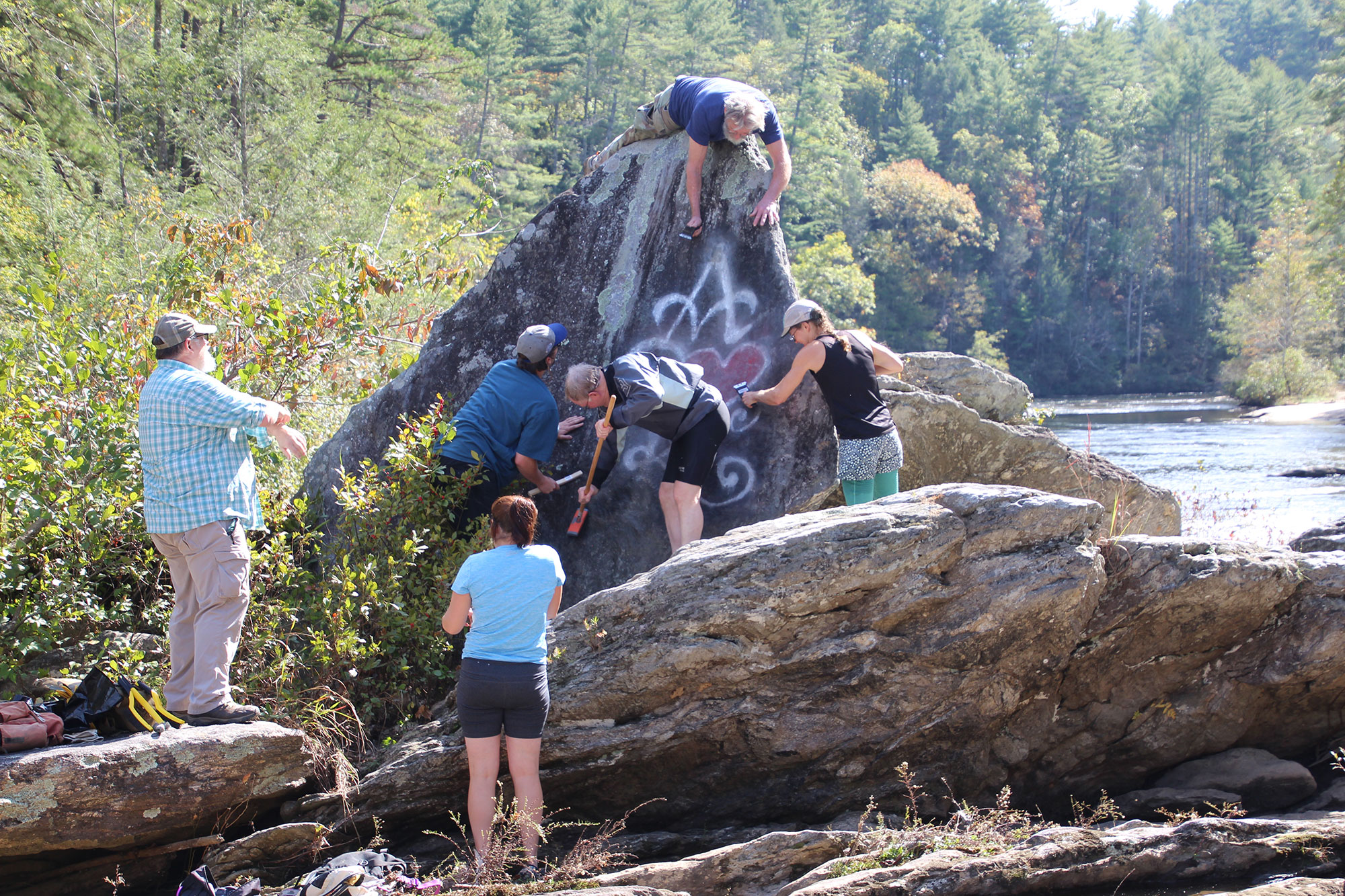
We’re launching a “Chattooga Stewardship Initiative,” to provide opportunities for all of us to be better stewards of the magnificent Chattooga River watershed. Our initial effort was to remove graffiti from rocks at Sandy Ford on the Chattooga River. Now, we will focus on cleaning up trash on public land in various areas of the watershed.
Each stewardship field trip will take place on the 3rd Saturday of the month, from 11:00am to approximately 2:00pm. We’ll provide garbage bags. Please bring your gloves, water, and snacks. Our goal is to collect at least 1,500 pounds of trash over the course of the next year – please consider joining!
Dates & Locations
All dates are on a Saturday!
February 17th
Site: Sutton’s Hole
Meet on the corner of Hwy. 76 east and Forest Service road 290 in GA.
Directions from Clayton: Take Highway 76 East for 7.4 miles to Sutton’s Hole Rd (also known as USFS Road #290). Sutton’s Hole Road is a small, gravel road on the right, approximately .3 miles after Southeastern Expeditions. If you reach the Highway 76 Bridge over the Chattooga River, you have gone too far.
March 17th
Site: Sandy Ford
Meet at the Sandy Ford parking lot in GA.
Directions from Clayton: Take East Savannah Street for .2 miles until it turns into Rickman Drive. Continue straight on Rickman Drive for .5 miles. Turn right onto Warwoman Road and continue for 5.3 miles. Take a right onto Sandy Ford Road. Turn right to stay on Sandy Ford Road and then continue onto John Houck Road for .4 miles. Turn left onto Sandy Ford Road. Continue on Sandy Ford Road for approximately 3.5 miles to where it ends in a gravel parking lot, which is immediately adjacent to the Chattooga River.
April 21st
Site: Earls Ford
Meet at the Hatch Camp and Art Farm, and then carpool to Earl’s Ford Road.
Directions from Clayton: Take East Savannah Street for .2 miles until it turns into Rickman Dr. Continue straight on Rickman Drive for .5 miles. Turn right onto Warwoman Road. Continue on Warwoman Road for 7.5 miles. Turn right onto Earls Ford Road and follow for .5 miles. Turn right onto Joe Speed Road and follow for .1 mile. Hatch Camp and Art Farm will be on the right.
May 19th
Site: Woodall Shoals
Meet at the Woodall Shoals parking lot in SC.
Directions from Clayton: Take Highway 76 East for 11.1 miles into South Carolina. Turn right onto State Road S-37-538, also called “Orchard Road” and follow for .4 miles. Turn right onto Woodall Shoals Road and follow for approximately 2 miles to a parking lot.
June 16th
Site: Highway 28 Bridge
Meet at the “fisherman’s parking lot” in SC.
Directions from Clayton: Take East Savannah Street for .2 miles until it turns into Rickman Dr. Continue straight on Rickman Drive for .5 miles. Turn right onto Warwoman Road. Continue on Warwoman Road for 13.2 miles. Turn right towards Highway 28 (GA-28 S). Turn right onto Highway 28 (GA-28 S). Continue on Highway 28 for 1.9 miles into South Carolina. After crossing the Highway 28 Bridge over the Chattooga River, take the next left into the “fisherman’s” parking lot.
Directions from Seneca, Westminster, Long Creek: From Highway 76, turn right onto Chattooga Ridge Road. Continue for 9.4 miles. Turn left onto Highway 28 S W and follow for 5 miles. “Fisherman’s parking lot” will be on the right, just before crossing the Highway 28 Bridge over the Chattooga River
Google Map Link from Clayton
Google Map Link from Seneca, Westminster, Long Creek
July 21st
Site: Burrell’s Ford
Meet at the Burrell’s Ford parking lot in SC.
Directions from Clayton: Take Highway 76E into South Carolina for 10.9 miles. Turn left onto Raines Rd and follow for 1.6 miles. Turn left onto State Road S-37-14 and follow for .3 miles. Turn right onto Cassidy Bridge Road and follow for 7.4 miles. Turn right onto State Road S-35-198/Whetstone Road and follow for .7 miles. Turn left onto Highway 28 SW and follow for 1.9 miles. Take a slight right onto SC-107 N and follow for 10.2 miles. Turn left onto USFS Road #646 and follow for 2.5 miles to a parking lot on the right.
Directions from Seneca, Westminster, Long Creek: From Highway 76, turn right onto State Road S-37-14 and follow for 1.5 miles. Turn right onto Cassidy Bridge Road and follow for 7.4 miles. Turn right onto State Road S-35-198/Whetstone Road and follow for .7 miles. Turn left onto Highway 28 SW and follow for 1.9 miles. Take a slight right onto SC-107 N and follow for 10.2 miles. Turn left onto USFS Road #646 and follow for 2.5 miles to a parking lot on the right.
Google Map Link from Clayton
Google Map Link from Seneca, Westminster, Long Creek
August 18th
Site: Bull Sluice
Meet at the Bull Sluice parking lot in SC.
Directions from Clayton: Take Highway 76E into South Carolina for 8.5 miles. Turn left into the “Bull Sluice” parking lot just after crossing over the Chattooga River.
Directions from Seneca, Westminster, Long Creek: Take Highway 76 towards the Chattooga River. The “Bull Sluice” parking lot will be on the right before Highway 76 crosses over the Chattooga River into Georgia.
September 15th
Site: Thrift’s Ferry
Meet at the first camping area on the left, near the start of the Thrifts Ferry Road in SC.
Directions from Clayton: Take Highway 76E into South Carolina for 9.3 miles. Turn left onto USFS Road #795, also known as “Thrifts Ferry Road.” Continue on Thrifts Ferry Road to the first camping area on the left, which is just a short distance from the start of the Thrifty’s Ferry Road.