Southside Project – Current Status
On 11 July 2018, the Nantahala Ranger District of the U. S. Forest Service in North Carolina issued their “Draft Decisional Environmental Assessment” for the Southside Project. This document shows that the agency wants to move full steam ahead with this controversial project. Comments objecting to the Southside Project must be sent by Monday, August 27, 2018.
Southside Project – Details
The Southside Project proposal includes:
- Cutting 317 acres of timber: 196 acres of “2-age” harvests, and 121 acres of “group selection” harvests.
- Extensive, repeated herbicide applications throughout all timber harvesting sites, and on roads and skid trails
- Burning 37 acres, in combination with a separate but connected proposal to burn 722 acres at Bull Pen and 956 acres at the eastern portion of the project area around Jacks Creek.
Nearly 60% of the stands of timber offered for harvesting in the Southside Project are over 100 years old, and are prime candidates for old-growth restoration. At least two stands of timber are existing old growth, with trees near or over 200 years in age.
The Southside Project Area
The Southside Project is located in the Chattooga River headwaters in North Carolina, and is a 28,000-acre area stretching from the Whitewater River, over Chattooga Ridge to the Chattooga River headwaters of Jacks Creek, then over the East Fork of the Chattooga River just north of the SC/NC state line on Highway 107, then along the Bull Pen Road, just north of the Ellicott Rock Wilderness Area in the Terrapin Mountain Potential Wilderness Area, then across the Chattooga National Wild & Scenic River Corridor along the Bull Pen Road adjacent to the Ellicott Rock Wilderness Extension and the Slick Rock Scenic Area, and finally, across to an area near “Granite City” at the foot of Black Rock Mountain, adjacent to the Black Rock Natural Heritage Area on the outskirts of Highlands, NC. 18,000 acres in this “Analysis Area,”where the forest management activities are proposed, are lands managed by the Forest Service, that are contiguous with 10,000 acres of private lands, which will also be affected by these activities. This area encompasses one of the highest concentrations of wilderness, sections of National Wild & Scenic River Corridor, potential wilderness, unique backcountry, and designated scenic and biologically protected areas in the Southern Appalachian Mountains.
Background
In March 2017, the Nantahala Ranger District issued a “scoping notice” for the Southside Project. The Forest Service admits that a large number of citizens responded with comments in opposition to the proposed project. Then about a year later, on February 16,, 2018, the Nantahala Ranger District published a “Draft Environmental Assessment” for the Southside Project, and asked for public comments (as required by the National Environmental Policy Act [NEPA]). The Forest Service proposed to conduct management activities within a large area of public lands in the Chattooga headwaters, as described above. They claim the purpose and need for this activity is “… to improve, or maintain, wildlife habitat, species diversity of stands, soil and water resources, and forest health through vegetation management and other treatments.” The “treatments” the Forest Service is proposing call for “2-age” timber harvesting (a modified form of clearcutting) on the majority of stands proposed for cutting; “group selection” timber harvesting; herbicide treatments on hundreds of acres to cultivate “crop trees;” and, controlled burning. The proposal also includes building roads and skid trails for logging.
The Nantahala Ranger District claims that there is a need to create “early successional habitat,” to restore forests to a more native condition. Nearly 60% of the stands of timber offered for harvesting in the Southside Project are over 100 years old, and are prime candidates for old-growth restoration. At least 2 stands of timber are near or over 200 years in age. Old growth stands are extremely rare – only .5% (one-half of one percent) of these rare native forests remain in the southeastern US, and they should not be destroyed.
Old growth stands serve as examples of native forest that can be studied as blue prints for restoration, and as critical habitat for many species of plants and animals. Old growth forests, when connected across the landscape, could provide our best chance to adapt and mitigate the effects of climate change. Also, what the Forest Service has failed to acknowledge is that old growth forests will naturally provide needed early successional habitat as the trees mature, die and fall, which creates canopy gaps allowing additional sunlight to stimulate new growth. Old growth forests are true native forests that somehow escaped the slash and burning that occurred in the watershed at the turn of the 20th century, during the timber boom years when almost all of our native forests were destroyed. Remnant patches of old growth should be protected as a top priority of conservation biology.
We feel very strongly that cutting the last remaining old growth forest in one of the most biologically rich ecosystems on the planet, using the same slash and burn methods that destroyed the vast majority of our original “native” forests, is heresy! Consequently, we are spearheading an effort to get the Forest Service to withdraw the Southside Project. We have held public meetings, and worked with University of North Carolina students to document old growth using the latest scientific methods and Forest Service criteria. We have also filed extensive comments, and rallied the public to get involved.
Over 200 people commented on the Southside Project proposal during the most recent 30 day comment period, many of whom agreed with the Chattooga Conservancy and requested that the project be withdrawn. But on July 11th, District Ranger Mike Wilkins announced that he would be moving ahead with the project in spite of extensive, science-based objections filed by the Chattooga Conservancy and other NGOs, and an overwhelming public response to shelve the project.
What Can You Do To Continue To Fight The Southside Project
Now that Ranger Wilkins has decided to move ahead with his chosen alternative outlined in the Draft Decisional Environmental Assessment (EA) that cuts old growth stands and maximizes “crop tree” management, those who commented during the scoping period are eligible to object in writing during a 45 day “objection period.” The Chattooga Conservancy and several other conservation organizations have written Freedom of Information Request to obtain any new information from the Forest Service that will help with our written objection. We have a little time, since the objection period deadline is August 27th.
The best thing people can do to stay involved with this action is to keep checking this site. Our goal is to generate input to the Forest Service through an informed public. We will provide the information we discover in the coming days, and post it here so folks who have “standing” (those who made comments during the earlier comment period in March) can use it in a written objection. For those new to this fight, we will also push for a public meeting, and will inform people about places and times if we are successful. And finally, we are working on legal opposition, if we do not get the Forest Service to seek another alternative during the objection period.
Please stay involved to help us stop the Southside Project. Also, consider joining the Chattooga Conservancy, so you can be added to our contact list.
-
More Background: March 2017 Southside Project Scoping Notice
The Nantahala Ranger District in North Carolina has released a “scoping notice” for a proposed timber sale in the heart of the Chattooga River headwaters, called the Southside Project.
The proposed project would involve 352 acres of timber harvesting, extensive herbicide applications, and road-building. The Chattooga Conservancy has examined the details of the proposed Southside Project, and has also visited several of the proposed logging sites in the field.
We are opposed to this project as it is currently designed. The “scoping” notice comments were due on March 20, 2017, and a copy of our comments are below. Stay tuned for further updates on our work to stop the Southside Project as it’s currently proposed by the Nantahala Ranger District.
 Here are our scoping comments on the Southside Project.
General Findings
We are opposed to this project as it is currently designed, for the reasons stated below. We also base this opposition on our opinion that the Forest Service has failed to provide the public with vital information concerning this project, that is necessary to make an informed decision about the proposed action, which includes: information regarding stand age class; the presence of old growth timber within proposed timber harvest areas; the presence of old growth protection patches as designated; and, due consideration of the project’s negative effects on the Ellicott Rock Wilderness Extension Area, proposed North Carolina Natural Heritage Areas, scenic beauty, recreation activities, biodiversity, wildlife and fisheries.
The Southside Project, as currently proposed, would damage the ecological and aesthetic character of public lands in the Highlands-Cashiers area. It would also unfairly/negatively prejudice the ongoing revision of the Land and Resource Management Plan (LRMP) for the Nantahala-Pisgah National Forest. The project should be re-designed to protect special places in the project area and postponed until the new LRMP is in place.
Standing
The Chattooga Conservancy is a non-profit grassroots conservation organization working to protect, promote, and restore the natural ecological integrity of Chattooga River watershed ecosystems; to ensure the viability of native species in harmony with the need for a healthy human environment; and, to educate and empower communities to practice good stewardship on public and private lands. The Chattooga Conservancy has an organizational interest in the proper and lawful management of public lands within the Chattooga River watershed, including the Sumter, Nantahala-Pisgah and Chattahoochee-Oconee National Forests. Members, staff, and board members participate in a wide range of recreational activities on these national forest lands, including those areas within the Nantahala National Forest that are proposed for management activities in the Southside Project scoping notice. The Chattooga Conservancy represents approximately 600 total members that support our work.
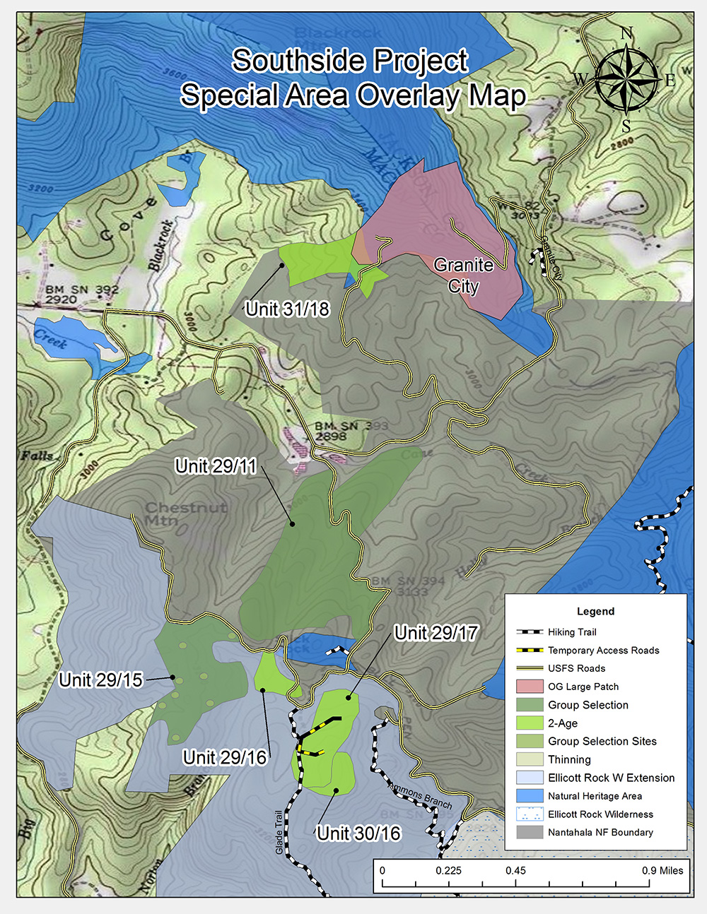
The Chattooga Conservancy claims standing to participate in the public land decision-making process on the grounds that it has been involved in national forest land management issues concerning the Chattooga River watershed since its formation, including the current proposed project. Our members have sought and continue to seek solitude, forested scenery, old-growth stands, and hiking, fishing, hunting, paddling, rafting and photographing experiences within the Nantahala National Forest, including the portion of the project area that would be affected by the Southside Project. Our collective membership includes professional photographers and recreational guides whose livelihoods depend, in part, on the remote and beautiful nature of the Chattooga Wild and Scenic River, including the project area, remaining intact. Other members also rely on the opportunities for solitude and seclusion provided in the headwaters region of the Chattooga River. (A map “Southside Project Special Area Overlay Map” should be used for reference for the following narrative)
Jacks Creek is a Brook Trout Stream & Feeds the Walhalla State Fish Hatchery (Units 40/21 and 40/42)
The Southside Project calls for logging in the steep terrain around Jacks Creek, near Highway 107. Jacks Creek is one of the few remaining wild brook trout streams in the area. It also feeds into the East Fork of the Chattooga River, which, in turn, feeds the Walhalla State Fish Hatchery. Logging and herbicides could harm brook trout populations in Jacks Creek by diminishing required environmental conditions—namely, cold, clean and clear water. It could also adversely impact the Walhalla State Fish Hatchery. In addition, logging in this area would also have a negative impact on, and be visible from, the Foothills Trail. The Forest Service should not permit logging that could degrade Jacks Creek, and the Foothills Trail.
Old-Growth on Brushy Mountain (Unit 35/41)
The Southside Project calls for logging and road construction on top of Brushy Mountain. This area is a wildlife corridor connecting Terrapin Mountain with the Ellicott Rock Wilderness, and contains a beautiful, old growth hardwood forest—over 200 years old—exhibiting outstanding diversity. (Note that the Forest Service’s CISC data [continuous inventory of stand conditions] for unit 35/41 is incorrect.) Old and diverse forests provide excellent habitat for a range of fish and wildlife species, and add to the unique aesthetic character of the Highlands-Cashiers area. The Brushy Mountain area also lies within viewshed of Ravenel Park (Sunrise Rock) and multiple homes on Sagee Ridge. The Forest Service should not log, or build a road, on top of Brushy Mountain. Regarding the adjacent unit 35/42, the Forest Service’s CISC data indicates that this stand could be well over 100 years old, and therefore we suggest that this area should be managed for old growth restoration, contiguous with the old growth on the summit of Brushy Mountain.
Natural Heritage Area and Granite City (Unit 31/18)
The Southside Project calls for logging within the proposed Blackrock/Granite City NC Natural Heritage Area, within 3,000 feet of Granite City, a popular recreation destination. A Natural Heritage Area is an area of land or water that is important for the conservation of the natural biodiversity of the State of North Carolina. Logging within a Natural Heritage Area would reduce its ability to contribute to ecological diversity. Logging here would also degrade the aesthetic and recreational experiences at Granite City. The Forest Service should not log in Natural Heritage Areas.
Designated Old-Growth Near Granite City (Unit 31/18)
The Southside Project calls for logging near Granite City. In addition to being located within a Natural Heritage Area site, this area is also located within a designated old-growth patch. The Forest Service is required to manage designated old-growth patches for their old-growth characteristics, not for their timber products or early successional habitat. In addition, trees in Unit 31/18 are over 150 years old and should be managed as old growth. The Forest Service should not log in old growth and designated old-growth patches within the project area.
Slick Rock and Green Salamander Habitat (Units 29/11 and 29/16)
The Southside Project calls for logging adjacent t to the Slick Rock Natural Heritage Area and habitat for the Green Salamander. The Forest Service’s logging activities would negatively impact habitat for the Green Salamander, which is a federally-listed endangered species. The proposed timber harvest near Slick Rock, a known breeding and feeding site for the green salamander, would reduce humidity required by the Green Salamander in breeding sites on Slick Rock, and eliminate feeding areas. The Forest Service should not permit logging that would damage Green Salamander habitat.
Old Growth near Ammons Branch Unit 29/17 and Unit 30/16 propose to cut 29 acres of 100-year-old white pine contiguous with a patch of old growth forest identified in the Forest Service old growth study entitled “Carlson Old Growth Study.” We request that these unit/stands be withdrawn and managed as old growth restoration areas, to expand the old growth patch at Ammons Branch.
Wilderness Implications (Units 30/16 and 29/17)
The Southside Project proposes logging and road building activity in the Ellicott Rock Extension Area, which is currently being considered for wilderness designation in the new draft LRMP for the Nantahala-Pisgah National Forest. Logging in this area would significantly weaken its potential for wilderness designation. The Forest Service should not log or engage in road construction activities within the Ellicott Rock Wilderness Extension Area.
Scenery and Recreation (Units 29/16 and 29/17)
Heavy timber harvesting and temporary road construction along the Glade Mountain Trail would destroy scenery, and impact recreation use on the Glade Mountain Trail. The Forest Service should not log around the Glade Mountain Trail.
Herbicides We also oppose the heavy use of herbicides in the Southside Project. The long term effects of herbicides on human, biological and aquatic health are unknown.
Silvicultural Treatments In general, the Chattooga Conservancy opposes the Southside Project’s proposed application of 2-aged regeneration harvests, a variant of even-age timber management. Also in general, we would request un-even age silvicultural prescriptions and/or small group selection (size of the group no larger than twice the height of the tallest tree in the stand), which more closely mimic natural disturbances.
Whitewater River Sector We are also concerned about the proposed heavy, 2-age management along the Whitewater River watershed, contiguous with the Chattooga River watershed, and the overlap with the Whitewater River Natural Heritage Area that could cause sedimentation, and harm recreation, scenic and biological values.
For the aforementioned reasons, we strongly request that this project be re-designed to protect special places in the project area, and postponed until the new LRMP is in place. We also request that the Southside Project be re-designed and deferred because of the failure of the Forest Service to provide necessary information for an informed public process. In addition, we feel strongly that the project be withdrawn because it would prejudice the ongoing revision of the Nantahala-Pisgah Land and Resource Management Plan. When finalized, the revised forest plan should contain new and valuable information not contained in the current, outdated plan that was put in place 23 years ago.